| Tsunami Workshops |
 |
| 2004 Workshop |
| Introduction |
| Agenda |
| Meeting Minutes |
| Participants |
| Example |
| Coastal Community |
| Steering Committee |
| 2002 Workshop |
| 2003 Workshop |
| 2006 Workshop |
Tsunami Scenario Simulation Workshop
- Minutes -
October 28-29th, 2004
San Francisco, CA
Chair: Harry Yeh
Recorder: Irene Watts
Attendees: Bailey, Michael (Oregon State U.); Baldridge, Steven (Baldridge & Assoc.); Borrero, Jose (USC); Celia, Jean (Lincoln City); Crawford, George (State of Washington); Fritz, Hermann (Georgia Tech); Gonzales, Frank (PMEL, NOAA); Hansen, Roger (U. Alaska); Katada, Toshitaka (Gunma U., Japan); Keon, Dylan (Oregon State U.); Kuwasawa, Noriyuki (Gunma U., Japan); Lindell, Michael (Texas A&M); Liu, Philip (Cornell); Lynett, Patrick (Texas A&M); McCreery, Chip (PTWC, NOAA); Mercado, Aurelio (U. Puerto Rico); Moncada, Javier (Oregon State U.); Okal, Emile (Northwestern U.); Pancake, Cherri (Oregon State U.); Pestana, Juan (NSF); Petroff, Catherine (U. Washington); Preuss, Jane (Geoengineers); Teng, Michelle (U. Hawaii); Walsh, Tim (State of Washington); Watts, Irene (U. Rhode Island); Yeh, Harry (Oregon State U.); Yim, Solomon (Oregon State U.)
- Day 1-
I. Introduction (Harry Yeh)
This is the third in the Tsunami Scenario Simulation Workshop Series. The first was held at the University of Washington in September 2002, and the second at Oregon State University in August 2003. This workshop is critical to advance or even sustain our activities toward the goals. First, general characteristics of tsunami hazards were described:
- Tsunami is a rare event, which is very difficult to forecast
- Tsunamis have distinct behaviors and characteristics
- Difficult to predict and measure the tsunami genesis
- While the event is rare, the devastation of such an event can be very high
- Humans in general are not prepared for the event
- Short lead time before an attack so evacuation and information dissemination is critical.
- Broad disciplines must be consulted for natural hazard study
Then, integration schema for tsunami scenario simulations that was discussed in the 2003 workshop was presented. The components include:
- Seismic signals and tsunami generation
- Propagation
- Ground Shake Effects (i.e. liquefaction, shear band propagation)
- Warning
- Runup
- Evacuation
- Assessment and recovery
Motivations and benefits of the scenario simulations are:
- Alternative to full-scale field investigation
- Controlled event
- Lessons learned from simulated fieldwork
- Discover and identify critical problems through the integrated simulations
- By working on a common scenario from different aspects enhances collaboration in the broad multidisciplinary community
- Encourage us to follow through our findings and results for the practical applications and not just publish a paper
- Emphasize the real world applications and use the knowledge that is generated in order to a id and improve society
The simulation exercise should be based on a hypothetical but realistic coastal situation so as to:
- Develop framework for other individual research activities
- Circumvent the potential social and political concerns of a direct study at a specific location
- Vehicle to determine what research is still needed and apply what is known.
We need to develop virtual coastal community for scenario simulation and strategies to initiate integrated approach.
- How can we encourage participation ?
- How can we support the core activity ?
- Provide and maintain complete data available for the Virtual Coastal Community
- Scenario manager is able to identify a particular disaster scenario
- Modelers download data as input to their simulation or incorporate the results of a prior step in the modeling pipeline
- Results uploaded and disseminated
- Bring to the front what is being done now
- Components of Virtual Coastal Community:
- Bathymetry
- Topography
- Coastal Infrastructure
- Residential Buildings
- Population
- Land Use Information
- Geotechnical Information
II. Tsunami Scenario Simulation (Toshitaka Katada, Gunma Univ. Japan)
Overview:Continued development of a comprehensive disaster scenario simulation, which incorporates the following components:
- Integration of:
- Warning Transmission Simulation
- Evacuation Simulation
- Tsunami Simulation
- Estimation of Casualties
- Visualization of GIS Network
From the previous model analysis for Owase , Japan , it was found that individuals should evacuate the area immediately after a seismic event occurs in order to maximize survivors. Waiting for the official evacuation announcement may cause the delay for survival .
Model Shortfalls:
- All people are assumed to be in their homes during disaster which is not always the case in reality
- No individual response is accounted for
Due to these limitations of the previous model a new model was developed and a distinction made between the two models; Stopwatch vs. Clock Model.
- The Stopwatch model just simulates what happens before, during and after the disaster assuming that everyone is in their homes. In contrast, the clock model can be adjusted to look at the conditions for a tsunami disaster at different points of the day reflecting the daily activities of the community
These models are currently being used and open to people accessible via Internet.
Future Work:
- Generate a new Tsunami Scenario Simulation model for another seismic and tsunamigenic active areas in Japan
III. Current Tsunami Research Activities that may Contribute to Scenario Simulations
a) Organizational Decision Making and Household Response to Evacuation Warnings (Michael Lindell, Texas A&M)
Overview:
- Basic idea is to adapt ideas and foundations developed from studying evacuation procedures and behavior of hurricanes to tsunamis. There is some significant correlation but adjustments need to be made
- Fundamentally, densely populated areas take a very long time to evacuate.
- Need to define run up areas how far inland
- Aim is to reduce congestion of main transportation arteries to evacuate those who really need to evacuate
Quantitative Model of Evacuation Behavior:
- Identify inundation zones for different tsunami magnitudes
- Assess evacuation route system
People have a tendency to focus on the main arteries instead of taking the minor roads, which might even be more direct route to safety - Assess the demand of evacuation routes
b) Regional Cost of a Natural Disaster (Jose Borrero, USC)
Overview:
- Study aimed at the economics of a natural disaster and its effects on the communities' economy in the aftermath of the event
- Combine inundation simulation with economic model
- Model was specific to Southern California
Types of Losses:
- Direct: Business cannot operate due to damage during the event
- Indirect: Business can no longer operate or is economically hurt due to another business being inoperable due to damage
- Induced: Type of indirect loss specifically related to labor, (loss of job)
Current Study:
- Four scenarios were investigated using the aforementioned model increasing in magnitude of seriousness
- Model investigates different types of costs
c) Pacific Tsunami Warning Center : NOAA (Chip McCreeny , PTWC)
Overview:
NOAA is not performing research but working to get the information to the public as efficiently and quickly as possibleCurrent Work:
- Reign of influence stretches from Pacific Coast of United States to Hawaii and Japan
- Various wave gauges located in Pacific Ocean
- Wave Gauge network in Pacific Ocean still weak
- Takes a long time to get information from wave gauges and mostly from coastal buoys rather than from tsunami gages offshore
- Seismic network in Hawaii has some flaws
Challenges:
- Have had repeated false warnings which reduces the effectiveness of future warnings which could be accurate
d) Tsunami Warning Observation in Alaska (Roger Hanson, U of Alaska )
Overview:
Components
- Warning Guidance
- Hazard Assessment
- Model
- Inundation Maps
- Hazard Mitigation
Alaska Tsunami Center and Observation
University of Alaska Virtual Center supported by state and
federal agencies
e) NOAA TIME Center : Tsunami Research and Development (Frank Gonzalez, PMEL)
Overview:
- Reduce the impact of tsunamis on U.S. Coastal Communities
- Track research and transfer technology based on best available science and implement applications to establish operational capabilities.
Current Work:
- Working on developing tsunami forecasting in real time during the event
- Scientific products available
- GIS Compatible files and a free GIS interface
- Evacuation maps available
- Force the models to match the data
- Forecast with models with wave height that is site specific
Future Work and Goals:
- Need a formal recognized way to transfer technology
f) Hydrodynamic Modeling Integration (Patrick Lynett, Texas A&M)
Overview and Goals (Supported by the NSF ITR Program):
- Develop a coupled hybrid hydrodynamic computational model for the simulation of wave processes from deep water to beach
- Combining both offshore long wave models (ADCIRC) and near shore Bousinessq models which incorporate sediment erosion/accretion.
- Breaking waves and turbulence is a problem
Current Work:
g) National Tsunami Hazard Mitigation Program (Tim Walsh, Washington St .)
Overview:
- Improve the integrity of the seismic net to focus on tsunamagenic zones
- Real time tsunami detection
Current Work:
- Develop real time tsunami detection
- Develop tsunami evacuation routes and inundation zones
- Investigate the evacuation problem with the Cascadian Subduction zone
- Populated areas located on spits and areas composed mainly of sand
- Streets are inadequate so travel on foot is the only method of travel
- Liquefaction dangers
Future Work:
- Evacuation for some areas is not an option. Therefore investigate the options of creating shelter in place.
- Design must be resistant to both seismic and tsunami loading
- Creating building codes for everyday uses that will resist seismic and tsunami events
- Breakaway shear walls and pile foundation buildings
- Upper walls for shelter and flow through below the structure.
h) Landslide Generated Tsunami (Hermann Fritz, Georgia Inst. of Technology)
Overview (Supported by the NSF NEESR Program):
- New 3D experimental set up for granular landslide tsunami modeling at OSU
Previous Work (at ETH, Switzerland ):
- Parametric physical modeling study of 2D tsunami generation by subaerial granular landslide impacts
- Lituya Bay scale model of the 1958 landslide impact and tsunami run up
- PIV applied both to the tsunami generation and run-up
Starting Future Work (Supported by the NSF NEESR Program):
- Build novel granular landslide tsunami generator
- 3D experiments with both subaerial and submarine granular landslides at OSU
- Linking theoretical geotechnical model of initial landslide motion and physical hydrodynamic model
i) Ongoing Research on Tsunami Modeling, Landslide Generation Tsunami Runup and Forces ( Phillip Liu , Cornell)
Overview (Approach and Philosophy):
- Combine lab research and theory model to develop further
- Determine scale effects with laboratory experiments at OSU
- Computer models used to extend the parameter range that can be covered.
Turbulence Model:
- Generate slide and study the hydrodynamic response
- Main goal is to find if they can characterize the response via landslide characteristic from different slide shapes and composition
- Tsunami forces on structures
- Model can detail turbulence
- Lighthouse project
Future Plan:
- Change the diameter of cylinder
- Change of water depth
- Group of cylinders
j) Field and Laboratory Tsunami-Structure-Foundation Interaction Modeling and Simulation (Solomon Yim, OSU)
Overview:
- Tsunami overtopping a peninsula
- Tsunami effects on structures
Current Work:
Future Work:
- 3D Analysis Model
- Flexible structure and soil foundation
- Fluid-Structure-Structure-Interaction
- Parallel and Super computing
- More modeling of structure
k) Facilitating Access to Tsunami Models (Cherri Pancake, OSU)
Overview:
- Inconsistency in data style and location
- Hard for users to repeat path when searching for information
Tsunami Digital Library:
- Targeted to non-researchers but useful for researchers
- Applies intelligence protocols
- Personalizes search over time
Portal:
- Provide unified place to call to sites
- Self updating
- Sorts answers (results of search)
Not Just Links:
- Intelligent to searching and indexing
- Rank document relevance
- Frequency of key terms and citations
- Constant feedback asks which helps rating
- Stores favorites
- Keeps frequently visited pages handy
- Resume and modify search
Future Work:
- Archive projects proof of concept works
- Tsunami Computational Portal
- Shared Web portal which is for executing models via the web
- Directed at researchers
- One stop access to models
- Simplifies and streamlines
- Many difficulties for making things work together and homogenizing everything
- Concerns:
- ? Complex Infrastructure
- ? Geodatabase
- ? Security
- Two models have already been ported to ARSC
- Common formats for bathymetry/topography control
- Hardest part is acquiring reasonably complete bathy/topo data
Day 2
l) Tsunamis in 3D Bathymetry (Harry Yeh)
Overview:
- Variation in bathymetry does cause a variation in runup
- Want to know what the interaction between the wave and the bathymetry
IV. Sample Coastal Communities (Harry Yeh)
Three sample coastal communities were presented. Those may be used as bases for the development of an ideal hypothetical virtual community(s) for our scenario simulations.
Community A: Owase , Japan- Interesting Features
- Pocket Beaches
- Offshore Islands
- Power Plant
- Port facility with breakwaters and jetty
- River outflows and bridges
- Large commercial buildings
- Present Data
- Topography: 50m data refinable to 5m
- Bathymetry: 50m nearshore , 500m offshore
Community B: Los Angeles and Long Beach CA
- Interesting Features
- Heavy industrial use
- Container port facility
- Oil transfer
- Cruise Ships as well as fishing fleet
- Oil and container storage facilities
- Present Data
- Topography: ?
- Bathymetry: 3 sec resolution grid
Community C: Long Beach , WA
- Interesting Features
- Long spit presents extreme challenge for evacuation
- Inhabited throughout length
- Framing along the low areas and peninsula
- Data
- Still being acquired
V. Open Discussion (Harry Yeh)
Opening Comments:
- We need a deliverable product to be distributed to the community
- Without no funding, no significant progress has been made
- Funding
- No FEMA
- Need to tie the project into national defense, i.e. Homeland Security
- Tie operational costs to research
- Evacuations vs. Vertical Evacuation/Code for Construction
- Room for both to be examined
- Some places cannot be effectively evacuated
Frank Gonzales' Table:
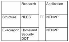
TT= Technology Transfer
Pay for a scientist to transfer the technology from one side to the other. Our scenario simulation will provide a channel for strong linkage between �Research� and �Application.�
Main Discussion Points:
- Hard to integrate entire package and present to different agencies with different specific focus.
- Transfer of existing technology and ideas even if it is not perfect (FG)
- Find out if there is a structure for inter-agency cooperation
- Use leverage
Homeland Security:
- Tsunami research does have terrorism application
- Study will investigate the following applicable aspects:
- Port Security -- Bomb going off and creating tsunami
- Evacuation routes
- Disaster scenarios
- Vulnerability after attack
Pilot Program/Project (HY):
- Send to homeland security
- Community Push
- Create a full U.S. example in order to generate awareness of the current tools and the importance of using and further developing these tools.
Should the individual pieces get funding on their own ?
Ideas:
- Initiate collaborative structure
- Develop goals for state
- Sample product available in 6 months
NEES Grand Challenge:
- Physical simulation
- Need two facilities
- Shake table
- Centrifuge
- Wave tank
- Need to include geotech and structure research
- How to evacuate: Social engineering
- Site Characteristics/Specifics
- Develop comprehensive list of applications
- Land use planning
- Building use planning
- Transportation route planning
- Critical facilities and critical infrastructure planning
- Lifelines location and protection
- Emergency communications
- Decisions on emergency classification
- Warning timelines
- Systematic needs assessment
- Risk Assessment
- Risk Education
- Key interactions (e.g. effects of transportation cut off on use of critical facilities
- Technology Transfer
Juan Pestana of NSF discussed NSF's NEES program:
- Currently, no new funding is being dispersed because of budget constraints
- Only will get 90% of funds from the previous year
- At the moment, all funding is depleted
- $20M for operational costs, $9M for research this year. $50M for research over the next 3 years
- February deadline for Letters of Intent: Highly Recommended
- Mid March is the deadlines for proposals
- Eliminate conflict of interests
- Tsunami Program is perfect for NEES Grand Challenge
- Interested in cross disciplinary Team
- Geographically, Ethnically, Gender diversity important
- Need more than broader impacts
Juan's Tips:
- Don't give an exact timeline or the reviewers will know that the work has already been done
- Show some detail for timeline: �Evaluate the first year and change the timeline as we see fit�
- Don't promise to do everything
VI. Summary (Pancake)
- Is it worth doing at all if no one is willing to do it?
- Need concrete, useful outputs, not just workshops
- Need to provide output that end users need
- Benefits
- Researchers: better chance of results being reflected in practice
- Response managers: realistic estimates of timing
- Planners: need improvements to building codes
- Strategies
- Create a functional core that could be leveraged by both research and application efforts
- Consider adding an evacuation model to HAZUS
- Explore relationship between suddenness of tsunamis and that of terrorism
- Explore possibility of human-induced tsunamis
- Funding
- Natural hazards largely off the board now that FEMA defers to Homeland Security
- NEHRP probably best possibility but now through NIST
- Try to bring in stakeholders to provide support
- Distinguish between research and development needs
- Research: use virtual communities
- Applications: Focus on real community
- Current sources for researchers present
- NSF, SeaGrant , ONR, National Geospatial Intelligence Agency, NTHMP
- Current State at NSF
- Still under continuing resolution and cannot commit to any new programs right now
- New NEES research solicitation still under revision
- Threshold for all 3 categories (individual, small group, challenge) will be reduced by 25%
- Process will be more like normal grant than last years
- Significant broader impact is a serious requirement
- Other possibilities for tsunami research
- GEO received a tsunami related proposal and attempted co-funding from CMS
- Synergy with other agencies: Juan needs a suggestion of contact points
VII . Workshop Outcome
- Initiate a structure for collaboration among funding agencies
- Would need to exploit personal contacts: Crawford will find a point of contact at Homeland Security
- NSF role should be partnering with other agencies who are willing to fund technology transfer activities
- Develop a sample product that can be shown to potential funding agencies
- Volunteers develop a sample product over next 6 months based on
- Katada and Yeh will improve the existing integration model
- Lynett and Liu will simulate tsunami propagation and runup for the virtual community model, as well as detailed flows around one of the oils storage tanks in the model
- Yim will run hydrodynamic/structural model to show some damage
- Bailey will integrate visualization
- Prepare a white paper to describe our integrated tsunami scenario simulations.
- Develop a workshop to kick off synergy among funding agencies. First we need to create a list of key contact, and we will invite them to the 2005 workshop.
- Create an advisory board to serve as voice of the tsunami community. It may require your time and effort for a trip to DC. Any volunteers?