|
|
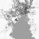
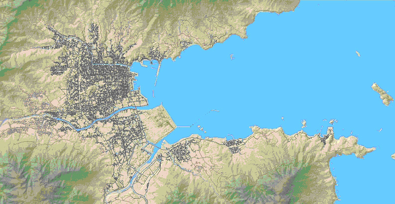
Example Community A: Owase, Japan
| Site Overview
| Characteristics:
| Densely populated site in a low-lying area, bounded by land
of higher elevation on three sides. Several major rivers empty
into the adjacent embayment, which is roughly rectangular (2 km
wide by 4 km long). Coastline is rugged, with several small
pocket beaches (300-400 m wide) along the north and south shores.
Many small islands are included in the data (but could be
removed).
| | Features of interest for tsunami models:
| Structures include power plant, oil storage tanks, offshore
terminal jetty, fishing port with quay and breakwater.
Seawall present on a large parcel of land located at the head
of the basin, protecting an industrialized area. Bridges span
the three major rivers located at the head of the embayment.
Wide variety of buildings, from small residences to large
commercial buildings. Roads are narrow and form a complex
network.
|
| Available Data
| Topography grid:
| Grid size is 50 m (can be refined to approximately 5 m);
based on LIDAR.
| | Bathymetry grid:
| Not available as GIS layer
| | Other GIS layers:
| Roads, rivers, political (city/town/village) boundaries,
geographic (sea/river/land) boundaries, building location and
size, location of seismic sensor; locations of individual
inhabitants
| | Issues:
| Bathymetry data is needed. Additional detail on
building structures (type of structure, use, and construction)
is highly desirable.
|
| Potential Uses
| Once additional data are incorporated into the
current database, the following simulations could be performed:
complex tsunami patterns within the embayment (there is a potential
for a tsunami-induced resonance within the 4km long embayment);
tsunami effects on the pocket beaches and local headlands; tsunami
overtopping of breakwaters and jetty; tsunami propagation along the
rivers; effects of tsunami actions on buildings, bridges, tanks and
other objects; overland flows at the power plant site; behavior of
floating bodies such as fishing boats; simulations for local warning
transmission, human behaviors and evacuation strategies; rescue
tactics and mitigation planning
| | | |
Example A, generated using available GIS data; area approximately
8 x 4 km
|
| |